a Taj MuttHall Dog Diary: January 2012

Tuesday, January 31, 2012

Almost 12 Miles

SUMMARY: We did it!

UPDATED Feb 1 10a.m. PST: Added two maps at end, link to interactive map, and notes about where the photos relative to the map.

Eight of us--six of us with dogs (for a total of 11 dogs)--met at 9 a.m. on Sunday to hike the Santa Teresa County Park portion of the Bay Area Ridge Trail and the optional Calero Creek/Los Alamitos Creek portion afterwards. The day started on the cool side but warmed up to at least the mid-60s if not near 70. In January! Funny Californians--here and elsewhere, almost with the same breath, we keep saying, "wow, we're so lucky with this weather!" and "wow, we're really in trouble if it doesn't start raining soon; hope it rains."

I was definitely the anchor (as in dragging behind) on this trip, even during the earlier part when I was feeling at my best and on the downhill when I thought I was moving along pretty well. Yup, mostly I saw everyone's backs. We started by going up and over three consecutive ridges.

(Photo A on MapMyRun map (copy of map at bottom of page).)


About an hour into the hike, in the park's central picnic area, we stopped at the human facility and also let the dogs have a rest and a drink.

(Photo B on MapMyRun map.)


Because (a) I was always behind, (2) I've taken so many photos at santa teresa, I hardly snapped any photos this trip. And I was still always behind. Still, looking east as we headed up the final ascent to Coyote Peak, the view of the observatories on Mount Hamilton was pretty clear for such a warm day.

(Photo C on MapMyRun map.)


Atop Coyote Peak--cumulative elevation gain of 1400 feet--we stopped for a variety of photos, including my usual pose with the Merle Girls at the usual place, but I got an unusual ear-kiss from the Booster in the process.

(Photo D on MapMyRun map.)


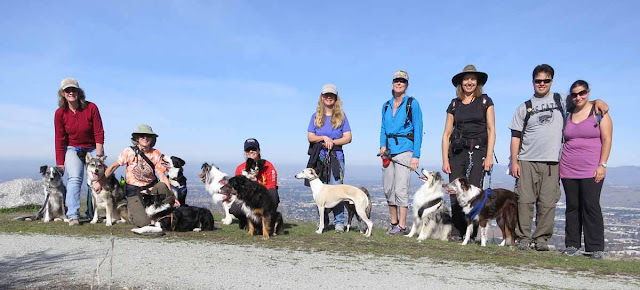
So here's our official shot, which has joined the others on our Coyote Peak Portraits page (link above).

Here we all are: 4 Border Collies, 3 Aussies, 2 Whippets, a Papillon, and a Craussie.

(Photo E on MapMyRun map.)


Here's one of the few Bay Area Ridge Trail markers, as we head out to the Rocky Ridge Trail to make our way back down.

(Photo F on MapMyRun map.)


Good thing the dogs were all on leash (a park requirement) or I'm sure they'd have all been breaking the speed limit (I let go of the Boost's and Tika's leashes while I stopped for the photo--they were ready to keep going).

(Photo G on MapMyRun map.)


Just another view of the group spread out along the single-track trail on our way down.

(Photo H on MapMyRun map.)


Half of the group split (as in, left, vamoosed, wimped out, headed for home) after the first nearly 7 miles; only four of us continued onto the second half of the planned trip. It was a long day--took us about 5 hours. It took longer than it might have otherwise because I slowed more and more as the day wore on. And, although the last 4.5 miles were completely flat, I and one other were both hurtin' more and more as we went. Over 11 miles in one day was a "stretch goal" for us. First the muscle or tendon on the outside of my right knee started hurting, and I had to slow to a stroll for it to not hurt. Then in the last half mile or so, the outer side of my left ankle started giving sharp pains. I loosened my boot and slowed even more to a very careful casual pace (trying not to limp) for it to not bother me, but I and the other gal were neither of us at our peak happiness.

None of us had ever seen a sign with its Dos and Don'ts with thumbs up and down before. Kinda cool.

(Photo I on second MapMyRun map.)


Even my dogs were slow by then, and again I worried a bit about Tika. But hard to tell--often if she's off leash, she perks up more than if she's trying to match my very slow pace.

I was pretty sure I'd hurt myself and would be ruing the day. But, lo!, Monday came--no soreness, no stiffness. And the dogs were running and playing with no signs at all that they were worse for wear. Tuesday came--still fine! This evening, we walked briskly the 2/3 of a mile to the school where I tossed the frisbee while walking the 1/4 mile around the field, then home again. By then, yeah, I was feeling that my leg muscles had been used and were not at their best, but I still walked home fairly briskly with no pain at all. Very, very good news indeed for my wonky knee and hip.

So I guess those nearly 12 miles in one day were just about the right length to give me a good workout, just past my reasonable limit, which I'm sure has upped my capacity for hiking distance (if I keep it up). It's still the uphill that I don't do enough of.

Tika was the oldest dog on the hike by about a year, and even she at 11 and Surely at 10 did fine for the whole 12 miles. And so did that tiny Papillon! Never flagged at all. Did better than I did.

Here's our route (the part between IBM gatehouse and "Start" is what I hiked and posted photos of Friday morning). We covered about 6.4 miles of Bay Area Ridge Trail. Only another 350  to go.


Here's a (Photo E on MapMyRun map.) ">link to the Santa Teresa MapMyRun section: Interactive, so you can select what type of display and also click the multi-arrow expansion icon in the corner to see a larger version.

Here are screen shots from that map: The terrain with elevations, and a satellite view version, with a chart at the bottom showing the angle of ascent and descent along the 6.9 miles we hiked.


Saturday, January 28, 2012

Testing the Waters

SUMMARY: A little Calero Creek Trail hike.
This coming Sunday, our Bay Area Ridge Trail group will be hiking Santa Teresa Park. The only part of the planned hike that I haven't been on is actually outside the park, flat along Calero Creek. (Yes,  there are places where you have to come down off one ridge to get to the next one. This is one such place.)

And the trail map notes that there is a "seasonal creek crossing." And a couple of photos that I found on the web seemed to show substantial water. I wanted to check it out before we all go there Sunday.

So on Friday morning the Merle Girls and I drove all the way to the park, hiked 1.2 miles along the trail, and then 1.2 back. Not a strenuous hike. Beautiful day, quiet trail, saw only two joggers, one biker, and one horse the whole 50 minutes.

Much of the trail led between an orchard and the creek. The first part of the trail, closest to the road, had a pretty fence separating it from the orchard. (Too much underbrush separated us from the creek to ever get a good view of it.)


That shortly became barbed-wire fence, but it is well-tended, taut wire fencing as the trail strolls amiably among tall, shady trees. 

But--huh--wonder what goes under here so often as to have pushed the wire up and worn a path? Going from the orchard to the creek? Or vice-versa?

The hills of Santa Teresa Park rise behind the orchard.


Looking back whence we came.  It's a gorgeous January day, temps in the mid-60s (mid-15s C).

I liked the lichen growing on the trees; you'd never notice it during the times of the year when the trees are fully leafed out.

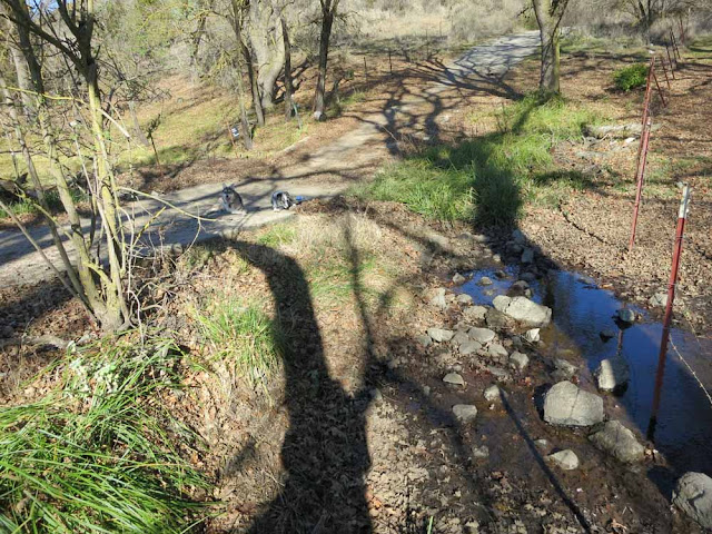
 Oh, and look at these cute dogs I found lying next to the path!

And, well, here we are at that seasonal crossing. The trail here is briefly concrete, which dips into the creekbed but not all the way down. With not much rain and a very small creek, the water just stops here next to the roadbed. There would have to be a lot of water for it to be high enough to go over the road--I don't think we'd want to wade through that! So this week, at least, we will stay high and dry if we get this far on the hike (coming from the other direction). But we can admire the twisty turny shade of that tall tree.

Mission accomplished (after a bit more hiking), we returned to MUTT MVR and headed home for some cool drinks and a rest. 

Friday, January 27, 2012

Foggy Night at the Agility Field

SUMMARY: Just some photos and notes.
I was going to post about Boost's training work, but instead, well, I became enchanted with the fog.

According to the newspaper's weather report, last Saturday South San Jose got .70 inches of rain and .25 more on Monday. My rain gauge says different.


In any event, everything around here is now saturated, and top that off with unseasonably warm weather this week. 

As a result, on the drive up to class last night, for the last mile I encountered clouds of fog drifting across and alongside the road, surrounding me in an odd, shifting tunnel of gray. When I alit from MUTT MVR, I admired the softly glowing agility field:

Kinetic the Papillon ponders her first agility lesson and carefully checks out all the dogs. Kinetic hikes with us regularly, many long miles without having to be carried even once.

The Merle Girls would like there to be some kind of action, here.

Our instructor shows us how it's done. At least, we think that's Ace and his handler out in the fog.

Boost's full sister (but not littermate) TCam also shows us how it's done, as the fog tries to take the field.

They can both really hustle!

And here, for your enjoyment, is the current #1 Mixed Breed AKC (I never dreamed I'd ever be saying that phrase!) agility dog, Roo. Is she good-looking or WHAT?

"Can haz photo?" ---or--- "Use the Force, Luka!"

But one of the best parts of the evening was The Owl's Song: From a Great Horned Owl, high in a dark tree, and I ran my video--you can admire the drifting fog, but then just listen--the perfect sound for a night like this:

On the way home, the fog had thickened enough that I drove that first mile--which I've driven hundreds of times at 40 MPH--at around 20, and at times on that curvy foggy road, 20 was a bit much as the road vanished and it wasn't entirely obvious whether it was vanishing into the fog or over the side of the mountain. Glad the fog cleared away as I descended the hill.

Thursday, January 26, 2012

Why Discouraged?

SUMMARY: Thinking about Tika's weekends and gnawing on statistics.
I keep thinking, well, Tika did Q 40% (4 of 10 Qable runs) this last weekend, and really, that's nothing terrible. But why does it feel so terrible? I mean, other than all the stupid things that kept us from Qing?

It's because it's feeling like a trend, and I don't like the way the trend is going.

For the 13 months from Sept 2010 to Sept 2011, covering 14 USDAA trials and 170 Qable runs, Tika's average Q rate was 71%. That includes two Regionals, a year apart. And she always brought home multiple placement ribbons. Not always first, but, f'rinstance, at this most recent Labor Day Regional, out of 16 runs against 14 to 18 other dogs, we came home with four 2nds, four 3rds, and four 4ths.

Since then, things seem to be going downhill.

The late-september trial, 55% Qs.
The October trial, 40% Qs.
The November trial, 27% Qs.
December, 44%.
January, 40%. And no placements. Not one. Against half a dozen dogs.

Her Top-Ten point average per day for that 13-month period was 7.3. (Or--oh, wait--it might be higher than that because I didn't count Team top 10s. Huh.) Our average in the 5 trials since that period has dropped to 4.7 per day. Then, this last weekend--nothing. Zilch.

I've known that I've been lucky with Tika. I've known that she's getting older. But has she really gone past her peak and is plummeting that rapidly? Or am I just slacking off?

I think it's good that we've got a bunch of CPE trials coming up--they'll give me another benchmark for how she's doing compared to her average rate in that venue.

Tomorrow, on to more cheery stuff--training with Boost.